Global Remote Sensing Technology Market By Product Type (Active Remote Sensing and Passive Remote Sensing), By Application (Agriculture & Living Resources, Military & Intelligence, and Others), By Platform (Satellite and Aerial Systems) By Region and Companies - Industry Segment Outlook, Market Assessment, Competition Scenario, Trends and Forecast 2022-2032
- Published date: Apr 2022
- Report ID: 27765
- Number of Pages: 207
- Format:
- keyboard_arrow_up
Remote Sensing Technology Market Overview:
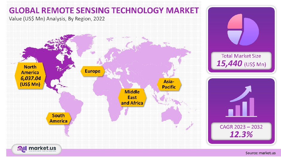
The global market for remote sensing technology was valued at USD 15,440 million in 2021. This market is expected to rise at a CAGR, of 12.3%, from 2023 to 2032.
This technology is used to obtain data about the Earth’s surface and evaluate its characteristics. It does not require physical contact with the studied surface but instead uses reflected or released light from satellites or aircraft.
The growing number of Earth observation ventures undertaken by many space agencies is the main driver of this market. Many countries took strict measures to prevent the spread of the COVID-19 virus pandemic. This directed to greater use of this technology to document environmental changes and monitor and curtail the spread of viruses.
Global Remote Sensing Technology Market:
Type Analysis
Passive remote sensing has the largest market share, at 58.10%. Passive remote sensor technology measures reflected sunlight on the earth’s surfaces in order to monitor their characteristics and analyze them. This technology can provide satellite imagery of high quality and is widely used in various earth observation applications.
Over the next seven years, active remote sensing will expand at a compound annual pace (CAGR) exceeding 7%. This technology emits visible light that can be used in surface monitoring and analysis. Active remote sensing technology removes all the drawbacks of passive sensoring. This technology is not able to measure surface characteristics at night.
Active remote sensing technology, which can also be used to measure forest structure or sea-surface topography, is widely available.

Application Analysis
The market share held by the military and intelligence was 33.15%. This is due in part to the rising adoption of technology and monitoring and preventing criminal and destructive activities by developed countries. China and Russia are also focusing their efforts on satellite images for defense applications. These factors are expected to boost demand over seven years.
The sector of disaster management will see the fastest CAGR, at over 15.25%, during the forecast period. This technology provides crucial information on natural disasters such as storms or volcanic eruptions.
The technology provides continuously updated information that aids authorities in making better decisions regarding evacuations, and the actions that must be taken following a disaster. This includes weather, infrastructure, agriculture, and other living resources.
Platform Analysis
In 2021, the aerial systems segment accounted for 68.50% of the total market. This is due to the increased use of drones, or Unmanned Aerial vehicles(UAV), in aerial mapping. Drones are cheaper and can collect more data faster than traditional methods. Additionally, these devices allow for surface mapping that provides high-quality data and covers an area that cannot easily be reached by satellites.
Key Market Segments:
By Technology
- Active Remote Sensing
- Passive Remote Sensing
By Application
- Agriculture & Living Resources
- Military & Intelligence
- Disaster Management
- Infrastructure
- Weather
- Others
By Platform
- Satellite
- Aerial Systems
Market Dynamics:
NASA, Japan Aerospace Exploration Agency, and European Space Agency joined forces in June 2020 in order to create a new dashboard of earth observation. This dashboard tracks changes in the environment that have affected people’s lives. The dashboard includes several satellite records that enable easy analysis and tracking of climate, economic activity, as well as changes in agriculture.
Smart city projects are increasing in popularity, which will lead to market growth. It is an asset to authorities involved in zoning. Many countries are now focusing their efforts to build infrastructure and investing heavily in their smart-city initiatives. This will be a significant driver of market expansion in the next few years.
Due to the high initial investments needed for the manufacturing of many components, this industry is not able to grow. Market players must be able to produce and encrypt information according to regulations in order to be considered a player. This reduces growth opportunities for market participants.
The increasing acceptance of exploratory and research-based applications is expected to drive market growth over the next seven years.Market growth will be driven by the increasing adoption of the Internet of Things, (IoT), technology within the agriculture sector. IoT is a combination of remote sensors, drones, robotics, and computer imagery to monitor and provide information to farmers to help them manage their farms.
IoT-based remote sense uses sensors on farms and transmits the data for analysis. Farmers can monitor the crops via an analytical dashboard, and then take action based on the insights.
Regional Analysis
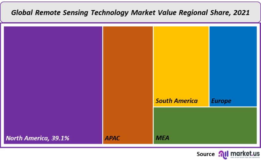
North America held a 39.10% market share in 2021, the largest. This market share is due in large part to the presence of key players such Lockheed Martin Corporation, Esri, General Dynamics Mission Systems, Inc Raytheon Technologies Corp., for precision-grid applications. The technology provides water resource managers with tools to minimize droughts and dry spells. It also allows them to match crop irrigation needs.
Asia Pacific is forecast to expand at a CAGR exceeding 13% during the forecast period. This is due in part to the increasing use of earth observation technology for infrastructure construction.
Remote sensing technology providers will be able to locate the most lucrative markets within the region, including India and Australia. It is possible that government initiatives like the Smart City Mission in India for urban infrastructure building will also help boost the regional market growth.

Key Regions and Countries covered in the rероrt:
- North America
- US
- Canada
- Mexico
- Europe
- Germany
- UK
- France
- Italy
- Russia
- Spain
- Rest of Europe
- APAC
- China
- Japan
- South Korea
- India
- Rest of Asia-Pacific
- South America
- Brazil
- Argentina
- Rest of South America
- MEA
- GCC
- South Africa
- Israel
- Rest of MEA
Market Share & Key Players Analysis:
Market leaders are turning more to inorganic growth strategies like mergers and acquisitions to increase their market share. UrtheCast, for instance, announced that it had acquired Geosys Technology Holding LLC in January 2019, a purchase valued at USD 20 million. This acquisition will allow the former company to improve its market position in geo-analytics for agriculture and solutions for farming.
Market players are also focused on gaining contracts from scientific and defense agencies in order to increase their market share. For instance, in February 2019, General Dynamics Information Technology, Inc. announced it received contracts from the National Geospatial-Intelligence Agency (NGA), an agency of the U.S. defense department for providing earth observation technologies.
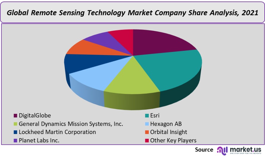
Companies invest heavily in research and development to create advanced products and technologies. development activities. Some of the leading players in the remote sensing technology market are:

Market Key Players:
- DigitalGlobe
- Esri
- General Dynamics Mission Systems, Inc.
- Hexagon AB
- Lockheed Martin Corporation
- Orbital Insight
- Planet Labs Inc.
- Other Key Players
For the Global Remote Sensing Technology Market research study, the following years have been considered to estimate the market size:
Attribute Report Details Historical Years
2016-2020
Base Year
2021
Estimated Year
2022
Short Term Projection Year
2028
Projected Year
2023
Long Term Projection Year
2032
Report Coverage
Competitive Landscape, Revenue analysis, Company Share Analysis, Manufacturers Analysis, Volume by Manufacturers, Key Segments, Key company analysis, Market Trends, Distribution Channel, Market Dynamics, COVID-19 Impact Analysis, strategy for existing players to grab maximum market share, and more.
Regional Scope
North America, Europe, Asia-Pacific, South America, Middle East & Africa
Country Scope
United States, Canada and Mexico, Germany, France, UK, Russia and Italy, China, Japan, Korea, India and Southeast Asia, Brazil, Argentina, Colombia etc.Saudi Arabia, UAE, Egypt, Nigeria and South Africa
Frequently Asked Questions (FAQ)
Q: What is the Remote Sensing Technology market size?A: The Remote Sensing Technology market size is US$ 15,440 million for 2023-2032.
Q: What is the CAGR for the Remote Sensing Technology market?A: The Remote Sensing Technology market is expected to grow at a CAGR of 12.3% during 2023-2032.
Q: What are the segments covered in the Remote Sensing Technology market report?A: Market.US has segmented the Global Remote Sensing Technology Market Value (US$ Mn) Analysis by Region, 2022 market by geographic (North America, Europe, APAC, South America, and Middle East and Africa). By technology, market has been segmented into active remote sensing and passive remote sensing. By application, market has been further divided into agriculture & living resources, military & intelligence, disaster management, infrastructure, weather & other applications. By platform market has been segmented into satellite and aerial systems.
Q: Who are the key players in the Remote Sensing Technology market?A: DigitalGlobe is a major industry participant. Esri, General Dynamics Mission Systems, Inc., Hexagon AB, Lockheed Martin Corporation, Orbital Insight and Planet Labs Inc., Other Key Players are the key vendors in the Remote Sensing Technology market.
Q: Which region is more attractive for vendors in the Remote Sensing Technology market?A: North America will have accounted this accounted for highest revenue share of 39.10% among the other regions. Therefore, the Remote Sensing Technology market in North America is expected to garner significant business opportunities for the vendors during the forecast period.
Q: What are the key markets for Remote Sensing Technology?A: Key markets for Remote Sensing Technology are the US, China, Japan, India, Brazil, Germany, UK, France, Italy, Spain, etc
Q: Which segment has the largest share in the Remote Sensing Technology market?A: In the Remote Sensing Technology market, vendors should focus on grabbing business opportunities from the passive remote sensing segment as it accounted for the largest market share in the base year.
![Remote Sensing Technology Market Remote Sensing Technology Market]() Remote Sensing Technology MarketPublished date: Apr 2022add_shopping_cartBuy Now get_appDownload Sample
Remote Sensing Technology MarketPublished date: Apr 2022add_shopping_cartBuy Now get_appDownload Sample - DigitalGlobe
- Esri
- General Dynamics Mission Systems, Inc.
- Hexagon AB
- Lockheed Martin Corporation
- Orbital Insight
- Planet Labs Inc.
- Other Key Players
- settingsSettings
Our Clients
|
Single User
$5,999
$2,999
USD / per unit
save 50% |
Multi User
$7,999
$3,499
USD / per unit
save 55% |
Corporate User
$12,999
$4,499
USD / per unit
save 65% | |
|---|---|---|---|
| e-Access | |||
| Data Set (Excel) | |||
| Company Profile Library Access | |||
| Interactive Dashboard | |||
| Free Custumization | No | up to 10 hrs work | up to 30 hrs work |
| Accessibility | 1 User | 2-5 User | Unlimited |
| Analyst Support | up to 20 hrs | up to 40 hrs | up to 50 hrs |
| Benefit | Up to 20% off on next purchase | Up to 25% off on next purchase | Up to 30% off on next purchase |
| Buy Now ($ 2,999) | Buy Now ($ 3,499) | Buy Now ($ 4,499) |


